

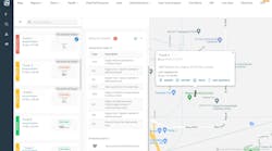


Networkfleet Inc. has added mapping capability with high-resolution satellite and hybrid maps for its web-based Networkfleet wireless fleet management system.
This new functionality gives fleet managers the ability to observe vehicles in a real-world setting with 3-D earth imagery for a more accurate and realistic depiction of a vehicle's location and its geographical surroundings.
Networkfleet combines GPS vehicle location tracking with precise diagnostic monitoring to give fleets a complete and accurate picture of their vehicle operations.
With the new mapping capability, fleet managers log in to a secure website and observe vehicles on a street map, a satellite map, or a combination hybrid map. They can also use the capability to more easily set up landmarks and establish geofences.
To learn more, visit www.networkfleet.com.